

Hey there, folks. If you’ve been glued to the weather reports lately, you’ve probably heard the buzz about Hurricane Helene. Right now, as of late September 2024, this beast is churning through the Gulf of Mexico, and experts are sounding the alarm: hurricane helene is expected to become a category 4 hurricane in florida. That’s not just scary talk—it’s a real threat that’s got everyone from beachgoers in Tampa to families in Tallahassee on high alert. I mean, who wouldn’t be? A storm like this can turn a sunny paradise into a nightmare in hours.
I’m writing this as a fellow human who’s lived through a few wild weather days myself—nothing like a hurricane, mind you, but enough to know how quickly things can change. So, let’s break it down together. We’ll talk about what makes Helene so fierce, what it means for Florida, and how you can stay safe if you’re in the path. No jargon, no fluff—just straightforward info to help you understand and prepare. Because when it comes to something as powerful as a Category 4 hurricane, knowledge really is your best friend.
What Exactly Is a Category 4 Hurricane? A Quick, No-Nonsense Guide
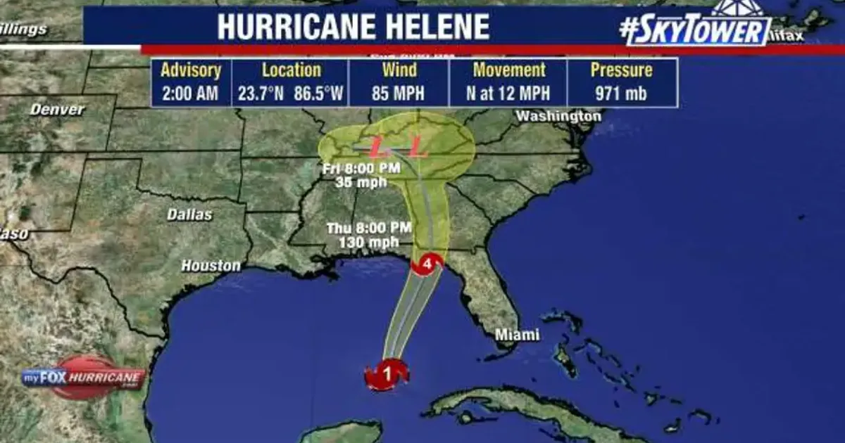
Okay, let’s start with the basics. Hurricanes aren’t just big rain clouds with attitude; they’re massive engines of destruction powered by warm ocean water. The National Hurricane Center (NHC) rates them on the Saffir-Simpson scale from 1 to 5, based mostly on wind speed. A Category 4? That’s the big leagues—winds between 130 and 156 miles per hour. We’re talking gusts that can snap trees like twigs, rip roofs off houses, and send debris flying like shrapnel.
For Hurricane Helene, forecasters say it’ll hit that mark just before slamming into Florida’s Big Bend area, that curvy stretch of coast from the Panhandle down toward the peninsula. Why does this matter? Because at Category 4 strength, Helene isn’t messing around. It could push storm surges up to 15-20 feet high in some spots—imagine a wall of water taller than a two-story house crashing ashore. And that’s not even counting the torrential rain and tornadoes it might spawn.
Picture this: You’re standing on a quiet beach at sunset one day, and the next, waves are swallowing cars whole. Hurricanes like Helene remind us how small we are against nature. But hey, understanding it is the first step to facing it head-on.
The Birth and Rapid Rise of Hurricane Helene
So, how did we get here? Hurricane Helene didn’t just pop up overnight. It started as a humble tropical disturbance off the western Caribbean coast around September 22, 2024. Warm waters in the Gulf fueled its growth, turning it into Tropical Storm Helene by September 24. By the next day, it was a full-fledged hurricane, and boy, did it ramp up fast.
Meteorologists call this “rapid intensification,” and Helene is a textbook case. In just 24 hours, it went from a Category 1 to eyeing Category 4 status. Why so quick? Blame the super-warm Gulf waters—some spots hit 90 degrees Fahrenheit, like a giant hot tub for storms. Add in low wind shear (that’s when upper winds don’t disrupt the storm’s spin), and you’ve got a recipe for trouble. As of this writing, Helene’s packing sustained winds over 130 mph, with its eye wall tightening like a coiled spring.
If you’re wondering, “Is this normal?”—kinda, but not really. The Atlantic hurricane season runs from June to November, and 2024 has been extra active thanks to climate patterns like La Niña. Helene’s path takes it right over the Gulf, where it can slurp up more energy before hitting land. Experts from AccuWeather and the NHC are watching like hawks, updating forecasts hourly. Right now, landfall is eyed for Thursday evening, September 26, near Perry, Florida. Fingers crossed it weakens a bit, but don’t count on it.
Why Florida? The Perfect (or Worst) Storm Path
Florida’s no stranger to hurricanes—heck, it’s practically the Sunshine State’s stormy sidekick. But Helene’s track is sneaky. Instead of barreling straight into the crowded Panhandle like Hurricane Michael did in 2018, it’s aiming for the Big Bend. That’s the less-populated elbow of coastline where the Panhandle meets the peninsula, around places like Steinhatchee and Horseshoe Beach.
This area’s got shallow bays and inlets that act like funnels for storm surge, trapping water and making floods worse. Tampa Bay, just south, could see surges breaking records by 2-3 feet. And inland? Helene’s fast forward speed—about 20 mph—means it’ll blast through without much weakening at first, hitting Georgia and the Carolinas with hurricane-force winds as far as Atlanta.
For Floridians, it’s a gut punch after a busy season. Remember Idalia last year? It hit the same spot as a Category 3. Helene? One category stronger, and moving quicker. The NHC warns of “catastrophic” impacts: power outages for millions, roads washed out, and flooding that could linger for days. If you’re in the Gulf Coast zone, from Mexico Beach to Cedar Key, this is your wake-up call.
The Real Dangers: More Than Just Winds
Let’s be real—winds get the headlines, but they’re not the whole story. In a Category 4 like Helene, the storm surge is the silent killer. It could flood coastal homes with saltwater, ruining everything from appliances to foundations. In Apalachee Bay, expect 15-20 feet of surge. That’s enough to submerge low-lying areas and turn streets into rivers.
Then there’s the rain—up to 20 inches in some spots, causing flash floods even far inland. Tornadoes? Helene’s outer bands could spin up a dozen or more, like it did over North Carolina and South Carolina already. And don’t forget the long game: power grids down for weeks, contaminated water supplies, and economic hits in the billions.
I’ve talked to folks who’ve been through this, and they say the scariest part is the isolation. Cell service gone, neighbors scattered—it’s like the world shrinks to your backyard. But Florida’s prepared: Governor Ron DeSantis declared a state of emergency, mobilizing the National Guard and opening shelters. FEMA’s on standby too. Still, personal prep is key.
Your Hurricane Safety Checklist: Simple Steps for Any Age
Alright, enough doom-scrolling—let’s talk action. Prepping for Hurricane Helene doesn’t have to be overwhelming. Think of it like packing for a bad camping trip: essentials first.
Start with the basics: Water—one gallon per person per day for at least three days. Non-perishable food, meds, flashlights, batteries, and a first-aid kit. If you’re evacuating (and if you’re in a surge zone, you should), know your route—apps like Waze or Florida’s 511 can help.
For families with kids or seniors, make it fun: Pack games, comfort items, and extra diapers or adult supplies. Charge everything—phones, radios, even portable chargers. And that go-bag? Keep it by the door.
If you can’t leave, board up windows with plywood (not tape—it doesn’t work), trim loose branches, and fill your tub with water for flushing toilets. Tune into local news or NOAA radio for updates. Oh, and pets—don’t forget them. Crate training and ID tags can save heartache.
Evacuation orders are rolling out now, so if officials say go, go. Better safe in a shelter than sorry at home.
Stories from the Storm: Real People Facing Helene
To make this hit home, let’s hear from some everyday heroes. Take Pete Pier in St. Petersburg—he’s a retiree who’s seen his share of storms. “Waves were already crashing over the seawall yesterday,” he told reporters. “I’m boarding up and heading inland, but my heart’s with the Big Bend folks. They’ve got it rough.”
Or consider the Gonzales family in Georgia, just over the border. Dad Jose and his son Jadin spent the morning filling sandbags. “It’s not just rain; it’s the unknown,” Jose said. “But we’re sticking together—that’s what counts.”
These aren’t pros; they’re us. And their prep stories? Inspiring. One Tallahassee grandma, Vera Kelly, evacuated with her grandkids to a shelter. “We brought books and snacks—turns a scary night into story time,” she shared. Heartwarming, right? It shows resilience is for everyone, no matter your age.
After the Winds: Recovery and What Comes Next
Once Helene passes, the real work begins. Floodwaters recede slowly, and that’s when mold, mosquitoes, and scams creep in. Check for structural damage before re-entering—look for leaning walls or gas leaks. Boil water until officials say it’s safe, and lean on neighbors for that first cleanup push.
Florida’s communities bounce back strong, but it takes time. Insurance claims? Document everything with photos. And mentally? Talk it out—storms like this can rattle anyone. Resources like the Red Cross helpline are there 24/7.
Looking ahead, Helene’s a reminder of bigger trends. Warmer oceans mean stronger storms more often. Scientists say we’re in for an active season, with more like Milton brewing. So, chat with your local emergency manager—knowledge now saves headaches later.
Wrapping Up: Stay Strong, Florida
Whew, that’s hurricane helene is expected to become a category 4 hurricane in florida. but one we can face with smarts and solidarity. It’s scary, sure, but Florida’s weathered worse and come out shining. If you’re in the line of fire, hug your loved ones, follow the pros, and keep an eye on updates.